CARTOSAT-1
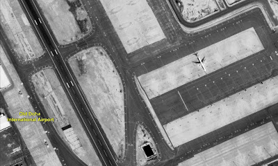
CARTOSAT–1 is the first Indian Remote Sensing Satellite capable of providing in-orbit stereo images. The images were used for Cartographic applications meeting the global requirements. Cameras of this satellite have a resolution of 2.5m (can distinguish a small car).
The Cartosat–1 provided stereo pairs required for generating Digital Elevation Models, Ortho Image products, and Value added products for various applications of Geographical Information System (GIS).
Cartosat-2 Series Satellite
Cartosat-2 Series Satellite is the primary satellite carried by PSLV-C40. This remote sensing satellite is similar in configuration to earlier satellites in the series and is intended to augment data services to the users.
The imagery sent by satellite will be useful for cartographic applications, urban and rural applications, coastal land use and regulation, utility management like road network monitoring, water distribution, creation of land use maps, change detection to bring out geographical and manmade features and various other Land Information System (LIS) as well as Geographical Information System (GIS) applications.
PSLV-C40/Cartosat-2 Series Satellite Mission was launched on Jan 12, 2018 at 09:29 Hrs (IST) from SDSC SHAR, Sriharikota.
Cartosat- 3
Cartosat-3 satellite is a third generation agile advanced satellite having high resolution imaging capability
APPLICATIONS
Cartosat-3 will address the increased user’s demands for large scale urban planning, rural resource and infrastructure development, coastal land use and land cover etc.
High resolution images captured by Cartosat- 3
List of the Cartosat satellite Series
Cartosat- 1
Cartosat- 2
Cartosat- 2A
Cartosat- 2B
Cartosat- 2C
Cartosat- 2D
Cartosat- 2E
Cartosat- 2F
Cartosat- 3
Cartosat- 2
Cartosat- 2A
Cartosat- 2B
Cartosat- 2C
Cartosat- 2D
Cartosat- 2E
Cartosat- 2F
Cartosat- 3


